Blog

Region-Specific Forecasts: 7/28-7/29

***POST EDITED FRIDAY 7/28/17 at 9:30PM***

SOUTHEASTERN PA:

Impacts: Moderate to heavy rain, scattered urban/small stream/poor drainage flooding, strong winds, isolated strong thunderstorms.

Timing: Scattered showers and thunderstorms will develop between 5pm and 10pm, from southwest to northeast. Steady to occasionally heavy rain is expected from 10pm through mid-morning tomorrow. Rain will taper-off from west to east late tomorrow morning and early tomorrow afternoon.

Rainfall: See map (*SE PA rainfall map is additional rainfall from 9pm onward)

Winds: East at 10-20 mph Friday and Friday night. Northeast 15-25 mph gusting 25-35 mph Saturday and Saturday night. Northeast 10-20 mph tapering to <10 mph Sunday.SE PA Rainfall.png

SOUTH-CENTRAL & SOUTHWESTERN PA:

Impacts: Moderate to heavy rain, scattered to widespread urban/small stream/poor drainage flooding.

Timing: Scattered showers and thunderstorms will continue through 7pm. Steady to occasionally heavy rain expected from 7pm early tomorrow morning. Rain will taper-off by mid to late morning tomorrow, although a few isolated showers may persist into early afternoon.

Rainfall: See map (*SW PA rainfall map is total rainfall from 2pm today onward)

Winds: East at 5-15 mph Friday and Friday night. North 10-20 mph gusting 20-25 mph Saturday and Saturday night. North 5-15 mph tapering to <5 mph Sunday.

sw pa rainfall.png

Storms Thursday, Heavy Rain Friday

Over the past 7 to 10 days, many parts of Pennsylvania have had to deal with their fair share of wet weather. Between severe thunderstorms and slow-moving systems, some areas have seen as much as 10 inches of rain.

Unfortunately, more of the same is expected towards the end of this week as we see a 1-2 punch of severe thunderstorms and heavy rainfall. Here’s the breakdown of what to expect:

Screenshot 2017-07-26 at 9.45.47 AM.png

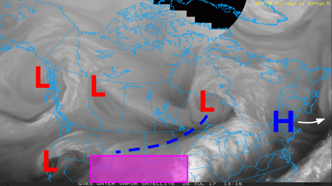
Looking at the current water vapor image across the US and Canada, there are a couple of features to note. First is our high pressure over the Northeast, providing us with a dry Wednesday afternoon. That’s going to be departing the region over the next 12-18 hours.

Behind that we have a strong low pressure system over Ontario, with a trailing cold front draped over Minnesota and the Dakotas. Also, we have a monsoonal low sitting over Colorado and Kansas, carrying with it plenty of moisture, as indicated by the convection over the central Plains. These two pieces will help to form Thursday’s thunderstorm risk.

Normally this would be a good setup for strong to severe thunderstorms, as we will have strong thermal gradients in place on Thursday. There’s no shortage of “fuel” for these thunderstorms. However, energy and vorticity to help those storms ignite will be lacking.

GFSMA_500_avort_042.png

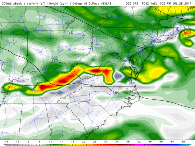
Above is the 500mb absolute vortcity (GFS) for 8pm Thursday. You’ll note that the NW-SE flow has steered the energy from our monsoonal low way south. As a result, the Virginias, North Carolina, and Kentucky are in prime position for severe thunderstorms. Us? Not so much. (except perhaps far SW PA)

Farther north, we will still have our cold front pushing through the region, meaning that some thunderstorms are not out of the question. This front, while not an overly impressive trigger in-and-of-itself, will have marginal support ahead of it across PA and NY to spark some isolated activity. The isolated part is important. Many places will remain dry on Thursday with the passage of this front. But any storms that do develop will have a fairly good chance of going severe, with damaging winds the primary concern. A severe thunderstorm outlook for tomorrow will be posted sometime tonight.

So overall, Thursday isn’t a major deal.

Then things get really abnormal for late July standards. Our low pressure over the Ohio Valley and Mid-Atlantic on Thursday will move across the Appalachians and weaken. However, the energy from this system will transfer to an additional area of low pressure off of the Delmarva and southern NJ coast for Friday. This is a setup more typical of late fall/winter, rather than summer. It’s basically a “Miller-B” storm.

For those not familiar with a “Miller-B” storm, below is a diagram. It’s not a perfect representation of how our system will play out, but it is fairly close. Obviously since this is summer, we won’t be seeing any snow out of it. 😦

MillerTypeB.gif

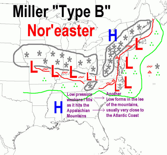
We have our remnant monsoonal low pushing eastward across KY/WV/VA. As it hits the Appalachian mountains, another low pressure forms on the eastern side, somewhere in the Delmarva/S NJ/N VA region. This becomes our primary system as it rapidly strengthens (cyclogenesis) as it pushes northeast.

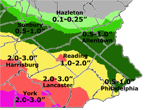
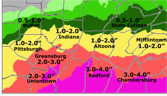
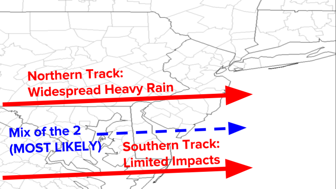
The major question regarding this storm is “where does it form?”. This is dependent on where our Thursday’s cold front-turned-stalled boundary parks. If it were to setup over southern PA/southern NJ, the majority of the state would see heavy rainfall and locally severe thunderstorms. If the boundary is further south (say over N VA-E MD), our odds of heavy rain reduce dramatically. 50-75 miles could be the difference between 0.50″ and 2-4″ of rain.

Screenshot 2017-07-26 at 10.30.55 AM.png

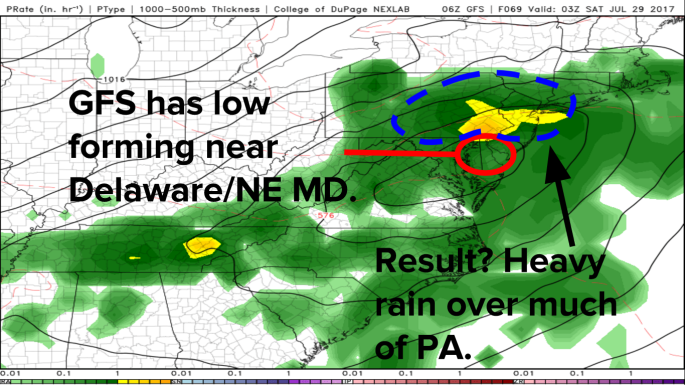
It’s pointless to post every model run, as the will all change over the next 24-48 hours. But just for reference, above is the 6z GFS run from this morning. In my opinion, this is a fairly reasonable solution. The Euro is farther southwest by about 40 miles, which is another plausible placement. The NAM has pretty much gone of its wheels, as it develops the system over SE VA (WAY too far south).

Screenshot 2017-07-26 at 10.43.19 AM.png

Taking in all the guidance, this appears to be the parameters for our system. There is still plenty of time to iron out the details, and of course, this has the potential to change and adjust.

Nevertheless, as our Nor’easter strengthens off the NJ/Long Island coast, we see winds back in from the northeast, bringing a heavy marine layer over the region. Add in gusty winds in the range of 20-35mph, temperatures in the 60s and low 70s, and we’ll certainly have a raw end to the week.

Due to these strong, gusty winds and grounds being saturated from recent rains, downed trees and power outages may become an issue, especially across eastern PA. Typically winds of this strength would not be a major problem, but in this Friday’s case it could prove otherwise.

Clouds and showers will likely linger into Saturday morning, before the system finally departs.

Severe Storms Possible Tuesday

Outlook.png

Showers and thunderstorms are expected to develop this afternoon and evening, bringing with it the potential for severe weather.

As of late this morning there are two disturbances located over the Ohio Valley region, moving east-southeast. In doing so, they’ll push across West Virginia, southern Ohio, and far southwestern Pennsylvania. 

DisturbancesOutside of some enhancement of shower and thunderstorm activity across SW PA, these disturbances won’t be of much importance to us. Today’s severe threat across PA, NJ, and into southern New England will be influenced by a pair of features across Michigan and northern Ohio, depicted below.

disturbances2.png

A lead wave is currently moving through western and central PA. Behind it, we are beginning to see more sunshine and a subsequent increase in instability. Further upstream into Michigan and Wisconsin, there is a rather potent mid-level disturbance, located on the periphery of its southern MCS counterparts (It isn’t producing much precipitation at the moment; mostly cloud-cover). 

This disturbance will push southeastward this afternoon & evening, and as it moves into a increasingly unstable air mass, showers and thunderstorms will develop.CAPE.png

A belt of sufficient CAPE will develop over Pennsylvania, New Jersey, and southern New England by mid to late afternoon. MUCAPE values of 1500-2500 J/kg and SBCAPE values of 1500-3000 J/kg are expected. Wind shear at 0-6km will range from 25-40 kt, which will be supportive of multi-cell storm clusters, capable of producing damaging wind gusts (despite mid level lapse rates being rather unimpressive). 

The best vorticity this afternoon and evening will be across central and southern Pennsylvania, as the secondary disturbances over IL/IN pass to our south. Elsewhere, vorticity will be decent, but not great (10-15 s-1). 

For most locations today, the severe thunderstorm threat is LOW. Storm coverage should be rather isolated through the majority of the afternoon hours before activity begins to increase. Widely scattered storm clusters are possible by this evening, but their unorganized nature should help to limit the severe potential.

A corridor of elevated risk exists along Interstate 80 in central and eastern PA, due to the potential for stronger, more individualized cells to form, capable of producing severe wind gusts. If the current disturbances over Illinois and Indiana enhance thunderstorm development to a greater degree than anticipated, this region of elevated risk may be extended to include southwest and south-central Pennsylvania. 

A Look at the Week Ahead: July 3-7

MONDAY:

Monday 7-03-17

A cold front moving across the Great Lakes region will trigger scattered showers and isolated thunderstorms Monday afternoon. The day won’t be a washout, but any given location will be at threat for a passing downpour. Highs will range from the lower 80s across the northern tier to the lower 90s in the Philadelphia metro. Winds will be from the southwest, at 5 to 15 mph.

TUESDAY (INDEPENDENCE DAY):

Tuesday 7-04-17.png

The cold front that moves through the region Monday will stall across Maryland and the Delmarva for your 4th of July. High pressure over southern Canada will attempt to build into the region, but the stationary front will be close enough to keep the threat for showers and thunderstorms in the forecast. The best chance for seeing any will be south of I-80. Most precipitation will diminish by early to mid evening, giving way to some clearing for fireworks displays Tuesday night. Highs will range from the upper 70s to the upper 80s.

WEDNESDAY:

Wednesday 7-05-17.png

The stationary front shifts south for Wednesday, allowing high pressure to move into the Mid-Atlantic and Northeast. We’ll see slightly cooler temperatures, but the bigger difference will be the drop in humidity. Wednesday appears to be our only guaranteed dry day this week. Highs will top out in the upper 70s and low-to-mid 80s. Overall, a very nice day for the first week of July.

THURSDAY:

Thursday 7-06-17.png

Wednesday’s relief from the heat and humidity doesn’t last very long. A warm front will push northwards over the Mid-Atlantic and Northeast on Thursday, bringing with it more tropical air. Dewpoints will be back into the low 70s ahead of an approaching wave of low pressure and trailing cold front. This system will spark widespread downpours and thunderstorms during the afternoon and evening. The potential exists for as much as 1-3″ of rain, which will raise the threat for localized flash flooding. Highs Thursday will generally be in the 80s.

FRIDAY:

Friday 7-07-17.png

Thursday’s low pressure and cold front push across the eastern seaboard by Friday morning. We’ll be between fronts for most of the day, which means there’ll be the risk for a few showers and thunderstorms. At this point, it doesn’t appear to be an all day rain. Highs in the upper 70s and low-to-mid 80s are expected.

Severe Thunderstorm Outlook-7/01/17

Severe T-Storm Outlook.png

Severe Thunderstorm Outlook – Saturday, July 1, 2017:

Scattered severe thunderstorms possible over central PA, eastern PA, northwest NJ, portions of central NY, eastern NY, upstate NY, VT, western MA, northern NH.

Isolated severe thunderstorms possible over western PA, extreme southeastern PA, central & northeast NJ, portions of CT, portions of central and eastern MA, NH, ME, southeast NY.

Main Risks: Isolated hail up to 1″ in diameter, isolated to scattered wind gusts in excess of 55 mph, very low risk for a tornado

Timing: 12pm through 9pm

Cities Impacted Include: Pittsburgh, PA … Harrisburg, PA … Scranton, PA … Allentown, PA … Philadelphia, PA … New York, NY … Newark, NJ … Albany, NY … Syracuse, NY … Boston, MA … Hartford, CT … Burlington, VT … Montpelier, VT … Concord, NH … Bangor, ME.

Severe Thunderstorm Outlook-6/30/17

Severe T-Storm Outlook.png

Severe Thunderstorm Outlook – Friday, June 30, 2017:

Scattered severe thunderstorms possible over northern PA, western NY, central NY, portions of eastern NY, extreme western MA.

Isolated severe thunderstorms possible over portions of PA, extreme northwest NJ, southeast NY, northwest CT, central MA, VT, NH, western ME, upstate NY.

Main Risks: Isolated to scattered hail up to 1″ in diameter, isolated to scattered wind gusts in excess of 55mph.

Timing: Afternoon, evening, overnight

Cities Impacted: Pittsburgh, PA … Scranton, PA … Wilkes-Barre, PA … Williamsport, PA … State College, PA … Bradford, PA … Erie, PA … Buffalo, NY … Jamestown, NY … Niagara Falls, NY … Rochester, NY … Binghamton, NY … Syracuse, NY … Albany, NY … Watertown, NY … Utica, NY … Springfield, MA … Worcester, MA … Burlington, VT … Montpelier, VT … Concord, NH … Nashua, NH … Manchester, NH … Portland, ME, Boston, MA, New York, NY … Newark, NJ … Hartford, CT.

Severe Thunderstorm Outlook-6/29/17

Severe Outlook.png

Severe Thunderstorm Outlook – Thursday, June 29, 2017:

Isolated severe thunderstorms possible over northwest PA, western NY, portions of central New York.

Main Risks: Isolated small hail up to 1/2″ in diameter and spotty wind gusts in excess of 55mph.

Timing: Late afternoon, evening

Cities Impacted: Erie, PA … Bradford, PA … Meadville, PA … Buffalo, NY … Jamestown, NY … Rochester, NY … Niagara Falls, NY … Watertown, NY.

Severe Thunderstorms Possible Sunday


A cold front moving across the Ohio Valley and Great Lakes region will trigger widespread showers and thunderstorms tomorrow afternoon, some of which may become severe. 

Tomorrow morning will feature scattered cloud coverage and a few widely isolated showers, which may inhibit morning heating. However, these clouds will clear out by early afternoon and in the presence of 65-75°F dew points, sufficient buoyancy will exist. There will be no lack of energy in place, with MUCAPE values of 1500-2500 and SBCAPE values of 1000-2250.

25-40 kt southwesterly shear (850mb) will lead to damaging winds of 55-70mph becoming the primary threat tomorrow afternoon, especially in multi-cell storm segments. Whether the storm segments themselves remain broken or form a larger “squall line” remains to be seen.

    The LOW and ELEVATED risk areas have been extended slightly further east over parts of northern and central PA due to the potential for pre-frontal discrete storm cells or segments to form. While not widespread, these storms will be capable of producing marginally severe hail (>1″ in diameter), along with damaging wind gusts of 60+ mph. Any storm that develops will produce intense lightning and torrential rainfall rates, with precipitable water values of 1.5-2.0 over most of the region.

     While tomorrow’s tornado threat is low, a brief spin-up cannot be ruled out, especially in any cells that do develop ahead of the front over central and eastern PA.

     As far as timing goes, storms will begin to develop as early as 1-3pm over NW PA. During that same time frame, storms may start to bubble up ahead of the front in C/E PA. From 3pm through 10pm expect a line of showers and thunderstorms to push eastward/northeastward across the state. The loss of heating after sunset will likely diminish thunderstorm intensity, especially cells ahead of the main line. However, since this event is being driven by strong dynamics aloft, activity will continue well into the overnight hours, unlike many typical summertime storms.

Preliminary Severe Thunderstorm Outlook (June 18, June 19)

Preliminary Severe Thunderstorm Outlooks for Sunday, June 18 and Monday, June 19.

Severe thunderstorms will be possible this weekend and early next week. Below are maps that illustrate where the greatest potential for severe weather lies each day. *Note-these maps are not intended to display the severity of the thunderstorms themselves. Simply, which areas stand the best chance of seeing severe storms.*